1/7


OSM Peak Finder
1K+ดาวน์โหลด
15MBขนาด
1.02.68(21-10-2024)เวอร์ชั่นล่าสุด
รายละเอียดรีวิวเวอร์ชั่นข้อมูล
1/7
คำอธิบายของOSM Peak Finder
แอพนี้ตั้งโปรแกรมเพื่อความสนุกสนานในเวลาว่างโดยไม่มีจุดประสงค์ทางการค้า เรายินดีรับฟังความคิดเห็นตลอดจนข้อเสนอแนะสำหรับการปรับปรุง
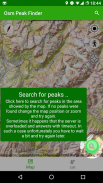
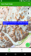
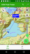
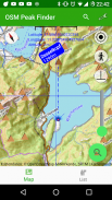
หน้าที่หลักคือการนำเสนอยอดเขาใกล้ตำแหน่งของคุณ การใช้เส้นแบริ่งซึ่งแสดงโดยเริ่มต้นที่ตำแหน่งของคุณ คุณจะสามารถระบุตำแหน่งและระบุจุดสูงสุดรอบตัวคุณได้อย่างง่ายดาย
ส่วนท้ายของแผนที่สามารถโหลดไว้ล่วงหน้าได้เช่นเดียวกับข้อมูลของจุดสูงสุด ดังนั้นมันควรจะเป็นไปได้หากคุณออนไลน์อยู่ โดยถือว่าคุณโหลดมันก่อนที่จะออนไลน์
ด้วยแถบค้นหา คุณยังสามารถกรองยอดเขาที่ขึ้นต้นด้วยระดับความสูงบางอย่างได้
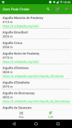
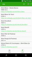
คุณยังสามารถแสดงรายการของยอดเขาโดยรอบและเช่น จัดเรียงตามระดับความสูงหรือชื่อ ในรายการ คุณจะมีข้อมูลเพิ่มเติม เช่น ลิงก์ไปยัง Wikipedia หากมี หรือการเข้าถึงสำหรับผู้ทุพพลภาพ
ขอให้สนุกกับการใช้และแจ้งให้เราทราบหากคุณชอบ
OSM Peak Finder--เวอร์ชั่น1.02.68
(21-10-2024)OSM Peak Finder - ข้อมูล APK
เวอร์ชั่น APK: 1.02.68แพ็คเกจ: eu.wuwer.osmpeakfinderชื่อ: OSM Peak Finderขนาด: 15 MBดาวน์โหลด: 472เวอร์ชั่น : 1.02.68วันที่ปล่อย: 2024-10-21 16:05:54หน้าจอขั้นต่ำ: SMALLCPU ที่รองรับ: x86, x86-64, armeabi-v7a, arm64-v8a
ID ของแพคเกจ: eu.wuwer.osmpeakfinderลายเซ็น SHA1: AA:79:48:CE:8A:15:8B:45:D0:5A:92:AF:62:0F:B1:12:0C:43:10:57นักพัฒนา (CN): Androidองค์กร (O): Google Inc.ท้องถิ่น (L): Mountain Viewประเทศ (C): USรัฐ/เมือง (ST): CaliforniaID ของแพคเกจ: eu.wuwer.osmpeakfinderลายเซ็น SHA1: AA:79:48:CE:8A:15:8B:45:D0:5A:92:AF:62:0F:B1:12:0C:43:10:57นักพัฒนา (CN): Androidองค์กร (O): Google Inc.ท้องถิ่น (L): Mountain Viewประเทศ (C): USรัฐ/เมือง (ST): California
เวอร์ชั่นล่าสุดของOSM Peak Finder
1.02.68
21/10/2024472 ดาวน์โหลด15 MB ขนาด
เวอร์ชั่นอื่น
1.02.67
25/2/2024472 ดาวน์โหลด36 MB ขนาด
1.02.66
4/8/2023472 ดาวน์โหลด10 MB ขนาด


แอปในประเภทเดียวกัน


English


